- First fully paved state
- Driving original US 66
- Ghost lanes
- Two routes south of Springfield
- Marx brothers
- Speed limits
- Superman
- Mississippi bridges
Which state was the first to have US 66 fully paved?
Glad you asked! Yeah, it was Illinois, which had a fully paved US 66 right from the start. Illinois used the already paved SBI (State Bond Issue) 4 as the roadbed for the newly created US 66. As noted later on this page, SBI 4 was not always the straightest path from Chicago to St. Louis, or even from one town to the next, but it ran in the correct direction and was already a hard surface. Over the years, US 66 would realign itself to be straighter and/or bypass the downtown areas of many locales. In one instance, the road shifted completely east in order to shorten the road from Springfield to St. Louis.
Can you drive on any of the original route in Illinois?
As a matter of fact, you can drive much of the original route, starting in Chicago. Route 66 originally followed Jackson, but when Jackson became a one-way street, Adams became US 66 in the other direction. However, Jackson is certainly still there, as is Ogden and other streets through the metropolitan area. Once you leave the Chicago area, you can still travel along alignments of US 66, although some were “upgraded” through time. One example is the four lane divided highway south of Joliet. Running for several miles, this is a precursor to I-55. Most of this follows the path of the original route, although the four lane was after that section became Alternate 66 (US 66 had bypassed Joliet by that time). And there are other opportunities as well, such as the turnoffs running through the various towns along Historic US 66, some of which have more than one alignment.
It’s worth taking a look at the section of road just to the north of Atlanta. This will give you an opportunity to drive on historic pavement, as well as to view pictures in the parking area at the north end of the road displaying when it was under construction. Another example, and there are many, is the section of road north of Lexington marked as Memory Lane. This narrow tree-lined pavement gives a taste of what it was like to travel the Mother Road when air conditioning in your car meant rolling down your windows.
Are the lanes next to the historical route original Route 66?
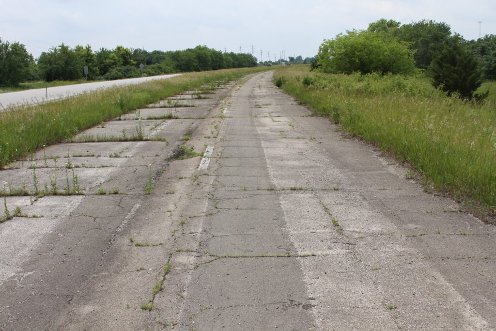
The lanes you may notice to the west of the two-lane historical Route 66 are actually the southbound lanes of the divided highway that made up the Route 66 alignment eventually replaced by Interstate 55. Parts of the divided highway still exist, for example the 15.9 mile long section starting south of Joliet and extending to north of Wilmington (listed in the National Register of Historic Places). However, most of the divided highway was abandoned many years ago, with only the northbound lanes remaining. The southbound lanes are, for the most part, in a state of decay, but often offers a look at the older composition of the highway, which was concrete slabs with control joints; however, much of these lanes have newer asphalt pavement, albeit in poor shape. Most of the bridges on the abandoned lanes are unsafe or missing, with barricades blocking them.
In some cases, the abandoned lanes trail off under I-55, and there are also instances where the former divided highway alignment is fully under the Interstate. You might also notice instances of roadbed heading off to the east or west that go nowhere. Often, these are crossing roads that were closed when the Interstate was constructed.
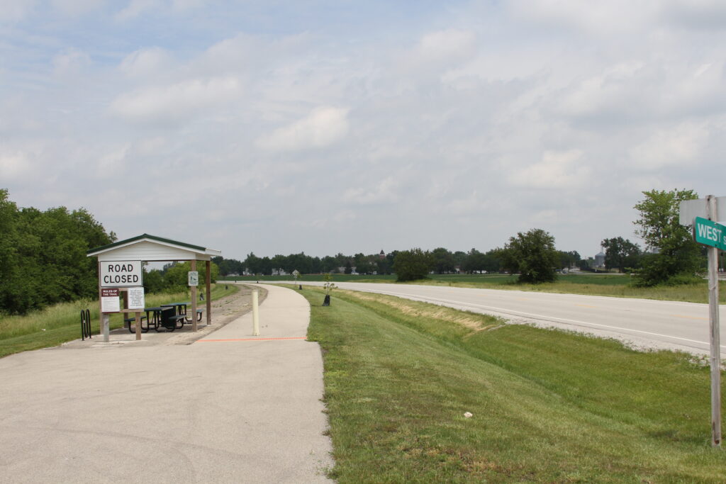
Some sections of the abandoned lanes have been reclaimed to serve as parks or bicycle/pedestrian paths or for turnouts, such as the one at Cayuga for viewing the Meramec Caverns barn sign. However, most of the lanes are not open for traffic of any kind. Considering the condition, it’s not likely the drive would be pleasant.
As far as being original, some of the divided highway bypassed previous alignments, while some is on top of the original roadbed. The original road, built as Illinois 4, tended to be quite narrow with thin pavement that could not withstand heavy traffic, especially military vehicles, that traveled Route 66.
Are there two different routes from Springfield to Saint Louis?
There are many locations where there are different alignments of Route 66, some originally going straight through towns along the way, with later alignments bypassing those towns or rerouting to avoid downtown areas, such as the three alignments in Pontiac. However, there is a major alignment difference running from Springfield to south of Staunton, one approximating the current I-55 alignment, the other the original reuse of Illinois Route 4, originally Illinois SBI (State Bond Issue) 4, lying farther west.
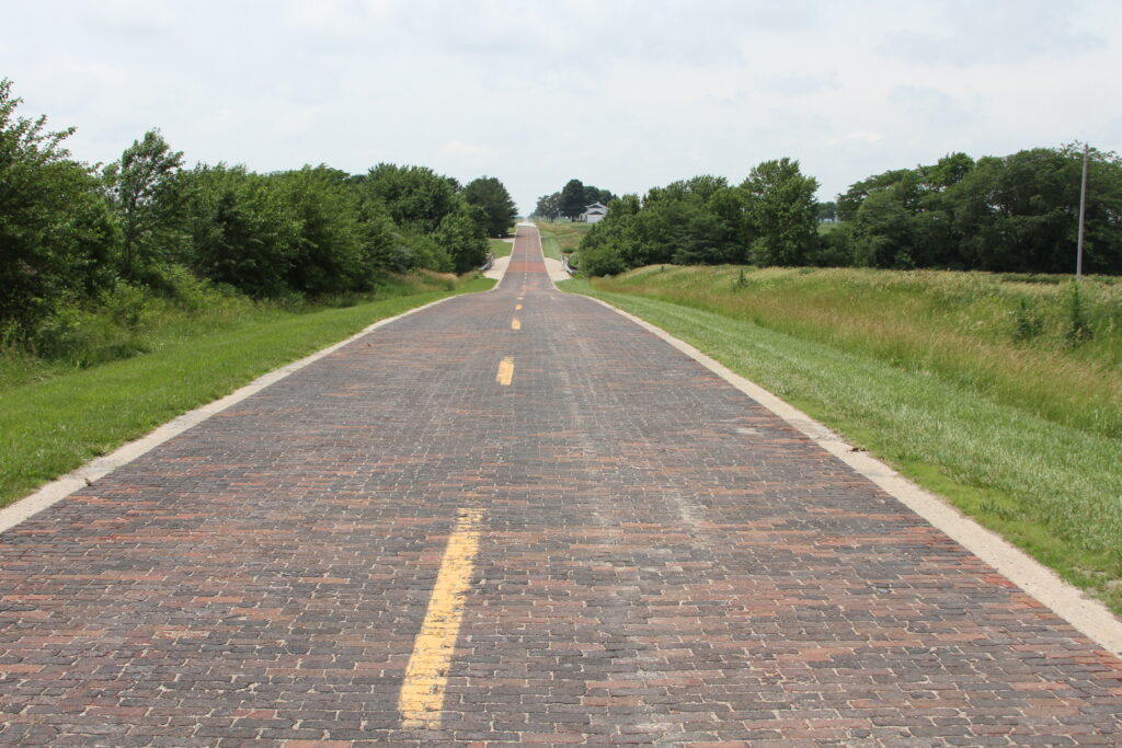
The original path of Route 66 in Illinois used Illinois 4, created in 1918, from Chicago to Saint Louis. Over the years, much of Illinois 4 has been renamed, although Illinois 4 still exists from Springfield south. This is the original path of Route 66, offering some of the more interesting aspects of the road. It can be harder to follow this path, but the key is to follow Illinois 4; there are some turnoffs along the way that are marked as historic 66, offering original alignments of Route 66 (and that of Illinois 4) that you will want to take. Some will merely give you a feel of the narrow zig-zagging road that was state-of-the-art in its time, while others offer even more. One of these is a portion paved in brick near Auburn, listed in the National Register of Historic Places, while another has a small section with turkey tracks frozen in time near Nilwood. This western alignment was only active as Route 66 from 1926 to 1930, when the alignment moved farther east. On a side note, the brick portion of the route was actually paved with brick after Route 66 had already relocated to the eastern routing; this, of course, does not remove its charm..
It may be worth noting that Illinois 4 was “retired” wherever it coincided with Route 66 in the mid-1930s, which is why this section designated as Illinois 4 still exists today, while the rest has disappeared from maps. Apparently this original routing of Route 66 was only meant to be temporary, with the later eastern alignment intended to be the permanent route once completed. However, with the following of the already existing Illinois 4, Illinois was the first state to have Route 66 entirely paved, which it was from the very beginning.
Why a duck?
While there’s no viaduct there, the stories you may have heard about the Marx family having a farm on what would become Route 66 are true. In 1917, Minnie, the boys’ mom, bought a chicken farm at the northeast corner of LaGrange and Joliet Roads, near where a White Castle currently stands. Groucho often talked of how she bought the farm in order to keep her sons from being drafted for WWI, but that is probably just another tall tale from Groucho. Gummo actually served, apparently the only son that was not rejected for one reason or another.
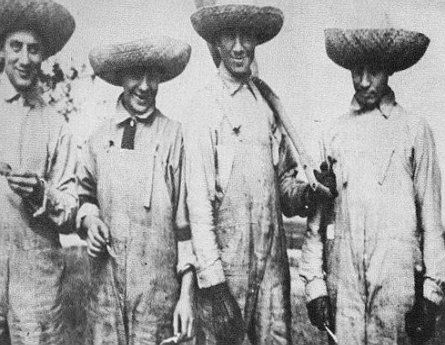
One thing people seem to agree on, though, is that the Marx family was not cut out to be farmers. 200 chickens were purchased, and coops built, with the intent to sell eggs. Groucho recalled that there were so many rats eating eggs they had to go into town to buy eggs to avoid the embarrassment when people came to visit the farm. In the meantime, Zeppo gave the raising of guinea pigs a shot, but nobody bought them and soon the basement was overrun with the furry critters, making it difficult to enter the cellar to pump water.
Groucho stated that they spent more time at Wrigley Field watching Cubs games than they did working at the farm (although it wasn’t actually named Wrigley Field until 1927, years after they left Chicago, still holding the original name of Weeghman Park until 1920). Eventually they gave up and moved to Chicago, with all of them leaving to return to New York City in 1920.
Reasonable and proper
If you’re old enough, you remember the days, starting in 1974, when highway speeds nationally were limited to 55 mph, causing much consternation and gnashing of teeth. The idea was to save gasoline, but those used to driving down the highway at 65 or 70 mph (or more) were not happy. That limit was relaxed in 1987. But what about before that “double nickel” mandated speed limit was in effect?
In Illinois, the speed limit on rural highways, such as Route 66, was set at 65 mph in 1957. The previous limit was 60 mph, set in 1951. Prior to that, there was “Victory Speed,” which reduced the limit to 35 mph from 1942 to 1945, the idea being to reduce the usage of rubber, which was a needed commodity for our efforts in WWII. That 35 mph speed limit matched the one set in 1923, which lasted until 1935. But that seems to leave some gaps, doesn’t it?
Well, between 1935 and 1951, exclusive of the Victory Speed years, the General Assembly basically eliminated highway speed limits for automobiles on rural highways. While discretion was given to the Illinois Department of Public Works and Buildings to set limits depending on engineering and traffic, there were often stretches of highway where “reasonable and proper” was the call. Of course, one person’s idea of that might be considerably different than another’s, but that’s how it was. The lack of a standard speed limit likely contributed to many of the accidents in that time span, especially on curvy roads with plenty of 90 degree turns, like Route 66. Most of us missed the “autobahn” years in Illinois, however, for better or worse.
But if you think speed limits, or the lack thereof, are a nuisance, just look back to 1903, when the Illinois General Assembly passed the first state law regulating motor vehicle speed. Going into effect July 1, 1903, it set a statewide 15 mph speed limit for all motor vehicles; municipalities were allowed to set their own limits on streets within their boundaries. The law also mandated drivers had to stop their vehicles immediately upon frightening a horse or other animal.
Does Superman live In Lincoln?
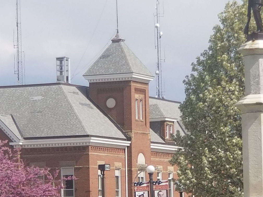
Atop the firehouse in downtown Lincoln, you may have noticed an odd structure. Sorry, it is not Superman’s changing room. The phone booth (itself an oddity these days) was placed there, not to give Clark Kent a handy place to transform, but to allow weather observers a place to watch for incoming storms. Not necessarily a job many of us would be clamoring for…perhaps it IS a good job for Superman, though. Be sure and check this out the next time you are in Lincoln.
How many US 66 bridges from Illinois to Missouri?
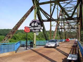
The first bridge crossing the Mississippi was the McKinley Bridge. That was followed by four more over the years, with the final one being that in use today, popularly called the Poplar Street Bridge, although that is not its official name (currently the Congressman William L. Clay Sr. Bridge). So there were five in total, with two no longer carrying any automobile traffic at all (the Municipal/MacArthur Bridge, which has no upper deck anymore, and the Chain of Rocks Bridge, which does have crossings on special occasions).